Ingest KITTI or nuScenes data, chunk by time, extract features — then search for the exact edge cases that break your localization or perception stack.
You have terabytes of rosbag / dataset logs. Somewhere in there are the 30-second clips where your system failed — but finding them means scrubbing through hours of data.
Your EKF diverged under a tunnel, but the log is 2 hours long. Which 10 seconds matter?
Perception worked in daylight but silently dropped detections as lighting changed. Where exactly?
The vehicle braked hard. Was it a false positive from the planner, or a real obstacle the detector caught late?
You need to share the exact failure scene with a teammate — not a 50GB bag file.
scene-db chunks your logs, computes motion features, and generates searchable captions. Here are real queries your team can run:
Sharp turns stress the EKF heading estimate. IMU gyro bias and wheel slip both accumulate here. Found 30+ deg/s peaks in KITTI and PPC data.
At 77 km/h, a 50ms GPS delay = 1.1m position error. LiDAR scan distortion from ego-motion is also maximal.
Parking, U-turns, crawling in traffic. Wheel odometry resolution limits dominate. GPS multipath in urban canyons.
After standstill, initial velocity is noisy. GNSS often reacquires with a position jump. IMU integration restarts.
Does the trajectory return to its starting point? scene-db detects loops and counts revisits for SLAM evaluation.
Braking tilts the vehicle forward. LiDAR FOV shifts, camera horizon drops. Detected 2.5+ m/s² events in KITTI.
Transitioning from motion-based to static perception. Object trackers often drop detections in this zone.
Low contrast, overexposure, rain on lens. VLM captions catch what rule-based features miss.
Multiple pedestrians, cyclists, turning vehicles — the combinatorial explosion that detectors struggle with.
Simultaneous turning and braking. All sensor modalities stressed: IMU coupling, wheel slip, pitch + yaw change.
GPS denied + lighting transition. Localization falls back to LiDAR/IMU while cameras adapt to darkness.
Don't know what to search for? Let scene-db find edge cases automatically with rule-based heuristics.
These scenes were found by running scene-db on 2912 scenes across 9 datasets (KITTI, nuScenes, GLIM, Cartographer, PPC, AIST Park, Flatwall, AlienGo).
Each GIF is a 5-second chunk extracted by the tool.
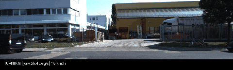
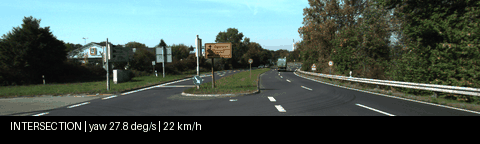
drive_0009 frame 196-244. High yaw rate with moderate speed. EKF heading estimate is under maximum stress. IMU bias and wheel slip both contribute to drift here.
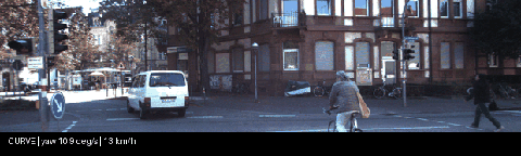
drive_0005 frame 0-48. Low speed + sustained yaw rate. Wheel odometry accumulates lateral error. GNSS multipath likely in this residential area with trees.
drive_0011 frame 98-146. Vehicle decelerating to stop. This is where late detection of obstacles or traffic signals has the highest consequence.
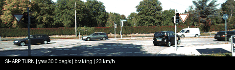
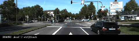
drive_0014 frame 0-48. Peak yaw rate in the entire dataset. Simultaneous turning and braking maximizes IMU error coupling. Wheel odometry is unreliable here.
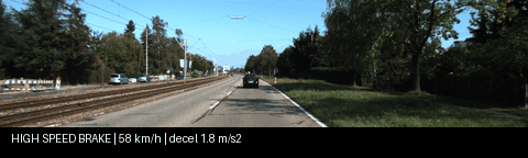
drive_0015 frame 0-48. Fastest sequence in the dataset. At 16 m/s, GPS update latency and LiDAR scan distortion from ego-motion become significant.
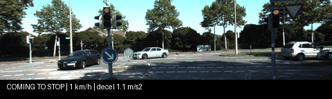
drive_0009 frame 392-440. Vehicle decelerating to a full stop. The transition from motion-based to static perception is where tracking often drops objects.
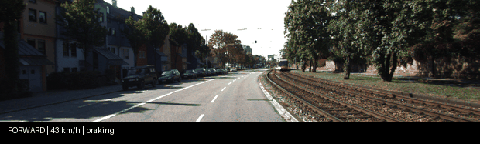
drive_0001 frame 0-48. Higher speed with braking events. At 43 km/h, even 100ms of fusion latency means 1.2m of position uncertainty.
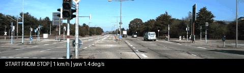
drive_0018 frame 147-195. After 15 seconds stationary, the vehicle begins to move. Initial velocity estimate is noisy. GNSS often reacquires with a jump here.
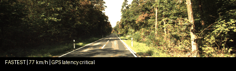
drive_0027 frame 147-187. At 21 m/s, a 50ms GPS update delay = 1.1m position error. LiDAR motion distortion is maximal. Any scan matching has to compensate aggressively.
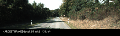
drive_0019 frame 147-195. Strongest deceleration in the dataset. Pitch angle changes during braking shift LiDAR FOV and camera horizon.
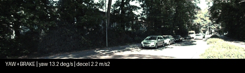
drive_0019 frame 392-440. Simultaneous high yaw rate and braking at near-stop speed. All sensor modalities are stressed: IMU coupling, wheel slip, and low-speed GPS noise.
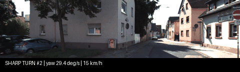
drive_0046 frame 98-124. Near-maximum yaw rate at very low speed. Wheel encoder resolution limits and IMU gyro bias dominate at this speed.
drive_0029 frame 294-342. Turning through a complex intersection. Map matching ambiguity is highest here — multiple lane hypotheses.
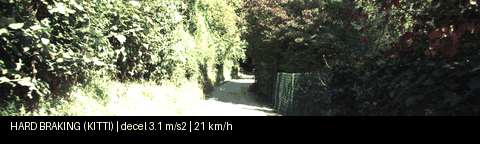
drive_0061 frame 637-685. Only hard braking event found across 25 KITTI sequences. Pitch change shifts LiDAR FOV and camera horizon simultaneously.
Ingest once, query forever. Export just the frames you need for debugging or retraining.
KITTI / nuScenes
5-sec time windows
speed, distance, yaw
rule-based or VLM
SQLite + embeddings
text or semantic
SQLite on disk. No Docker, no Postgres, no Elasticsearch. Install with pip, run from your terminal.
Optional GPT-4o integration generates rich scene descriptions from camera images. Falls back to rule-based if no API key.
Embedding-based similarity search with sentence-transformers. Find scenes by meaning, not just keywords.
Extract the exact images, point clouds, and IMU data for a scene. Feed it straight into your replay pipeline.
KITTI and nuScenes today. Same SceneChunk model regardless of source. Easy to add your own format.
ingest index search export — no YAML configs, no pipeline DSLs, no ceremony.
GLIM os1_128 (491 MB, 115s)
Ouster OS1-128 + IMU. Small, fast to download. Confirm your pipeline runs.
AIST Park (2.1 GB, 144s)
Max decel 11.2 m/s² across all datasets. Repeated hard braking events (8.4, 7.2, 6.9 m/s²). Tests if your ESKF/EKF tracks through violent acceleration changes. Ouster + IMU.
Flatwall (306 MB, 33s)
Wall-only environment where LiDAR scan matching degenerates. Without IMU, localization fails. The critical test for IMU-LiDAR coupling.
Cartographer 3D (9.3 GB, 20min)
20 minutes of continuous operation. IMU-only speed drifts to 6000+ km/h. Your SLAM must prevent this.
PPC Tokyo run1/run2
9.9 km with loop detected (2m closure). 1386 revisits. RTK-GNSS ground truth.
KITTI drive_0014 / PPC Tokyo run3
Up to 30.2 deg/s. Intersection turns that stress heading estimation.
AlienGo (774 MB, 344s)
Four-legged robot with Livox + T265 camera + IMU. Walking gait creates decel 29,693 m/s² and yaw 45,118 deg/s — 1000x more than any vehicle. The ultimate stress test for IMU preintegration and LiDAR-Visual-Inertial fusion.